Student Name(s): Grade:
Physical Geology 101 Laboratory
Topographic Map Lab I – Topo Basics
Introduction & Purpose:
Topographic maps are much scaled down two-dimensional
paper models of the Earth’s three-dimensional land surface. The characteristic that makes topographic
maps unique are contour lines, which are map symbols that express surface
relief – ground elevation changes across a given tract of land. Each contour line represents a continuous set
of surface point locations that have equal elevation. The topographic (“topo”
for short) map is an ingenious invention that helps humans navigate across the
Earth’s surface, and analyze the Earth’s surface morphology, and geology.
Learning how to create and read topographic
maps can be difficult, especially for those people who are not graphically
and/or three-dimensionally minded.
However, if the basic concepts of contour lines, map scale, and
coordinate positioning systems are properly understood, then the ability to read topographic maps
will come much easier. The purpose of this lab is to learn how to read,
interpret, utilize, and create topographic maps and topographic map profiles.
The major objectives of this laboratory
exercise are as follows:
1) Be able to interpret all the necessary map
information, including map scale, declination, contour interval, map symbols,
and map coordinates.
2) Be able to locate and identify features on a map,
including the use of map coordinates, identifying geographic features
Part I.
Instructions: Carefully read and analyze the section 9A in your lab manual – pages
168 through 184. Then complete the
following exercises found on pages 185 and 186 in your lab manual. Please use the copies of the figures in the
worksheet to complete your answers/
Section 9A Questions and Answer Sheet
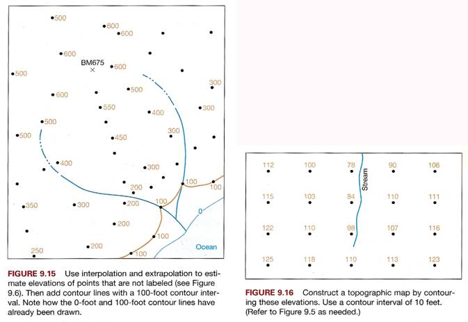
1. Draw contour lines with 100-foot intervals on
Figure 9.15. Refer to Fig 9.6 in manual
if needed.
2. Draw contour lines
with 10-foot intervals on Figure 9.16.
Refer to Fig 9.6 in manual if needed.
3. Color/shade in the area that represents the
top of the highest hill on the map in Fig. 9.17. Then
label
the following features: Ridgeline with “Ridge”; Round hill with “H”,
Saddle with “S”.
4. Place the correct
contour value in empty box on map in Figure 9.18. Then color/shade in the
area that
represents the lowest elevation on the map.
Finally, label the closed depression on
the map with the
initials “CD”.
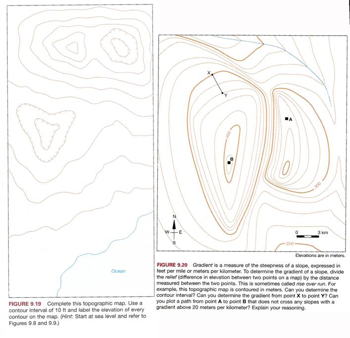
5. Complete the topographic
map in Figure 9.19 using a contour interval of 10 feet. Make
sure to label
each contour line with its exact elevation above sea level. Make note of the
closed
depression contour
lines.
6. Refer
to map in Figure 9.20 for completing the following questions:
a) The contour interval =
___meters b)
Total map relief = ____ meters
c) What is the slope gradient
from “X” to “Y”? = ______
meters per km
d) Draw a road from Point “A”
to Point “B” such that the road’s slope gradient does not
exceed 20
meter drop per kilometer. Hint: Why do hiking trails have “switchbacks”?
Work
Sheet for Part I. -
Questions #1 through #4

Work
Sheet for
Part II. Analysis of a Standard 7
½ Minute Quadrangle USGS Topographic Map
Instructions: Complete the following map analysis activities for a standard 7 ½
quadrangle topographic map supplied by your instructor.
1.
The size of the map is ______ minutes by ______ minutes
2.
The ratio scale is _____________________
3.
The verbal scale is _________________________________________________
4.
The contour interval is _______________
5.
The adjacent quadrangle to the south is ________________________________
6.
What is the maximum relief of the map? ________________________________
7.
When was this map last updated? _____________________________________
8.
What is the amount and direction of magnetic declination?
__________________
9. What is the exact latitude
and longitude of a point 1/3 of the way up from the bottom and 1/3 of
the way over from the left edge of the map?
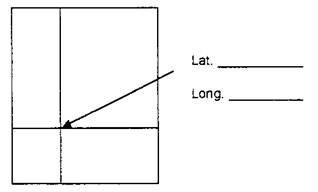
10. Locate that same point by
UTM coordinates: ____________E
____________N
11.
Is this point visible to a person standing due west at the edge of
the map? _____
12. How far away would that
point be from the person?
__________ft _________mi
13. What is the slope gradient
between that point and the nearest hilltop or mountain peak in feet per mile?
________________________________________________________________
Part III. Topographic Map
Laboratory Reflection
Directions: Write a reflection (minimum 100 words in
length) about your experience in doing the topo map
exercises lab today. Include the
following: 1) What was the purpose of the lab?; 2)
What did you actually learn from this laboratory?; 3) What did you find
interesting? 4) What were the problems and challenges you encountered; and 5)
what’s your opinion on how this lab was designed and executed.